 Courtesy of
Biblical Archaeological Review May/June 1997 Issue |
 BARGIL PIXNER |
| * I sincerely thank Professor James Tabor of the University of North Carolina at Charlotte, Dr. Rainer Riesner of the University of Tübingen and Professor James Strange of the University of South Florida for their great help in preparing this article. ** See Bargil Pixner, "Church of the Apostles Found on Mount Zion," BAR, May/June 1990; Hershel Shanks, "The Tombs of David and Other Kings of Judah," Jerusalem: An Archaeological Biography (New York: Random House, 1995), pp. 35-43. 1 Bargil Pixner, An Essene Quarter on Mount Zion? Jerusalem: Franciscan Printing Press, 1976; abstract from Studia Hierosolymitana I.- Studi archeologici in onore di P. Bellarmino Bagatti Jerusalem, 19761, p@. 245-286). 2 Josephus, Jewish War 5.145. |
MOUNT ZION, the highest spot in ancient Jerusalem, is where I live.* You can't miss our abbey south of the walled Old City. The squarish, fortress-looking building with the conical roof and four slender corner towers is our church-the Church of the Dormition of Mary. Next to it-the building with the prominent bell tower-is the Dormition Abbey, the traditional location of the dormition (the passing away) of Mary, mother of Jesus. just to the north is Zion Gate, leading into the Old City. To the east is a small minaret that overlooks the Cenacle building, where, according to tradition, Jesus ate his last Passover with his disciples in the "Upper Room" (Mark 14:15; Luke 22:12). On the ground floor of this building is the traditional tomb of David, a Crusader creation and surely not the site of the actual tomb.** On the southern slope of Mount Zion (southwest of the Temple Mount) is the famous Protestant Cemetery, where the great 19th- and 20th-century archaeologists Sir William Flinders Petrie, Conrad Schick and James Leslie Starkey are buried.
Back in 1973, when I was teaching Biblical topography and archaeology in the monastery's new theology department, the dean urged me to make a special study of the archaeology of Mount Zion.1 Early in my research I became intrigued with a passage by the first-century C.E. Jewish historian Josephus, who refers to a "Gate of the Essenes," which appears to have been in the neighborhood of Mount Zion. The Essenes, a separatist Jewish community, have lately become very famous because most scholars believe the Dead Sea Scrolls are part of an Essene library. This wall began in the north at the so-called Hippicus Tower [one of the three towers built by Herod for his Upper Palace citadel] and went [east] on to the Xystos, and reaching the Council House ended at the western Colonnade of the Temple. On the other side facing west, it began at the same starting point [Hippicus Tower], extended [south] through a place called Bethso to the Gate of the Essenes and turned thereafter facing south [but going east] towards the Pool of Siloam. From there it went again, now facing east [but going north], towards Solomon's Pool, and reaching as far as a certain place, which is called Ophlas [the Ophel], where it was joined to the eastern Hall of the Temple.2Each landmark mentioned by Josephus seems to be located at the end of a section of the wall. From the known landmarks in this description, I have inferred that the Gate of the Essenes must have been on Mount Zion at the southern end of the western section of the First Wall, just before it turned east across the Tyropoeon Valley toward Siloam. 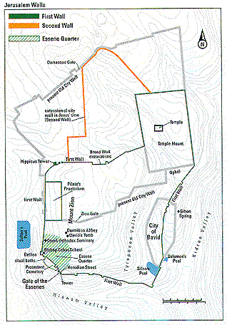 The first person to examine this critical region was Henry Maudsley, an Englishman. In 1874, in connection with some improvements to the Protestant Bishop Gobat School on Mount Zion, Maudsley explored the area and laid bare a large segment of rock scarp that had formed the base of Josephus's First Wall. He also found numerous ancient dressed stones-the remains of the First Wall, destroyed by the Romans in 70 C.E. To preserve these stones for study, he used several of them to construct a retaining wall outside the main gate of the school. Although over the years the school's name has changed (first to the American Institute of Holy Land Studies and more recently to Jerusalem University College), Maudsley's retaining wall remains outside the main gate.
In the 1890s the British archaeologist Frederick Bliss extended Maudsley's excavation. Expecting the First Wall to continue around the crest of Mount Zion, Bliss sunk a hole near what is now the parking lot of the restaurants and tourist areas just outside Zion Gate. He discovered a sewage channel beside an ancient street. He followed the buried street toward the southwest until it reached a gate in the ancient Jerusalem wall.
In his early reports in the journal of the London-based Palestine Exploration Fund, Bliss somewhat ecstatically identified the gate as the long-lost Gate of the Essenes.3 | ||
|
3 Frederick J. Bliss, "Second Report on the Excavations at Jerusalem," Palestine Exploration Fund Quarterly Statement 26 (1894), pp. 252-255; "Third Report on the Excavations at Jerusalem," Palestine Exploration Fund Quarterly Statement 27 (1895), pp. 9-25 (esp. P. 9). 4 Bliss and Archibald C. Dickie, Excavations at Jerusalem, 1894-1897 (London: Palestine Exploration Fund, 1898), pp. 16-20, 322-324. 5 Shortly after Bliss's excavation ended in 1897, just a century ago, the property of which the excavation was a part was purchased by the Anglican-Lutheran Church Union, thus enlarging the old cemetery where the first bishops of the Union-Michael Alexander (died 1845) and Samuel Gobat, for whom the school on Mount Zion was named (died 1878) -had been buried. 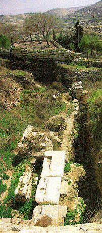
6 For a discussion of the main proposals, see the study of Rainer Riesner, "Josephus' Gate of the Essenes in Modern Discussion," Zeitschrift des deutschen Palästina-Vereins 105 (1989), pp. 105-109. 7 Pixner, Doron Chen and Shlomo Margalit, "Mount Zion: The Gate of the Essenes Reexcavated", Zeitschrift des deutschen Palästina-Vereins 105 (1989), pp 85-95 and plates 6-16, and "Mount Zion: Discovery of Iron Age Fortifications Below the Gate of the Essenes," in Ancient Jerusalem Revealed ed. Hillel Geva (Jerusalem: Israel Exploration Society, 1994), pp. 76-81; Pixner, "The History of the Essene Gate Area, Zeitschrift des deutschen Palästina-Vereins 105 (1989), pp. 96-104. 8 Geva, "Excavations at the Citadel of Jerusalem, 1976-1980," in Geva, pp. 156-167; Nachman Avigad, Discovering, Jerusalem (Nashville: Thomas Nelson, 1983). *See Nitza Rosovsky, "A Thousand Years of History in Jerusalem's Jewish Quarter," BAR, May/June 1992. |
Later, however, in a book describing the entire excavation, he wrote with less confidence. The sill, or threshold, of the gateway had several layers of stones, and he frankly admitted that he was unsure of the period to which each of these levels should be assigned.4 He also mentioned that the gateway excavation should not have been left exposed, for the beautiful slabs that formed the layers of the threshold would surely be scavenged by local residents and reused in the construction of houses in the Old City. Fortunately, the steep crater that Bliss left apparently collapsed quite soon, burying and thereby preserving the superimposed sills of the gateway.
I might never have had the courage to renew excavation at this site if I had known of Bliss's later doubts. Unaware, I began work in the spring of 1977, with the permission of the Lutheran and Anglican proprietors of the land and the Israel Department of Antiquities.5
As Bliss had detected, the gateway had several layers. We uncovered three distinct sills-the remains of three gates that had been built on the same spot over several hundred years. Working with me was an architect (my nephew) who noticed that the gate was joined to the rest of the wall in a way that indicated the gate must have been inserted into an already existing wall. This observation proved to be quite important as our excavation continued. After I opened up a limited area around the gate, two Israeli archaeologists joined me in the dig, architect Doron Chen and field archaeologist Shlomo Margalit. With limited finances and the help of volunteers, we worked together as a team for more than ten years.7 One of our most significant discoveries related to a long-standing scholarly debate about the expansion of Jerusalem in the First Temple period. All scholars agreed that the original City of David was confined to a spur, or ridge, extending south from the Temple Mount. But the date of the city's expansion across the Tyropoeon Valley to a western ridge, our Mount Zion, was intensely debated. The so-called minimalists maintained that the city remained limited to the much smaller eastern ridge until the Hasmonean period (second century B.C.E.). Numerous excavations (by C.N. Johns, Ruth Amiran, Avraham Eitan and Hillel Geva), however, found evidence of expansion onto the western hill as early as the eighth or seventh century B.C.E., in support of the maximalist position. 8 The argument was finally settled with the discovery of the so-called Broad Wall mentioned by Nehemiah (Nehemiah 3:8) and attributed to the Judahite king Hezekiah (727-698 B.C.E.). Excavated in the Old City by Nachman Avigad, this 23-foot-thick wall established the line of Josephus's First Wall (see map, P. 24).* Although Josephus had wrongly dated the wall to the time of King David and King Solomon, he was right to assign it to the First Temple period. The question nevertheless remained as to the location of the southern part of the First Wall. How did it pass across the southern flank of Mount Zion?
In 1988 we were lucky enough to find the missing link. Adjacent to our gate, on the southeast, arc the remains of a tower. We excavated on the northwestern side of the tower down to bedrock. There we found a finely hewn rock scarp, nearly 5 feet high, that had a small groove at the bottom, indicating that it might once have been a rock quarry. On top of the scarp was a wall built of medium-sized field stones, slightly worked into nearly rectangular shapes. Guessing that this was the outer face of a city wall, we looked for the inner face, which we found nearby to the north. The wall was nearly 8 feet wide. Additional soundings about 65 feet to the east revealed further sections of the inner face of this wall. Pottery sherds from within the core of the wall (both north and east of the tower) dated from the eighth to seventh century B.C.E. Accordingly, it was probably King Hezekiah who built this wall. The Book of Chronicles tells us, "and outside it [the ancient enclosure] he [Hezekiah] built another wall" (2 Chronicles 32:5). We had apparently found the southern segment of the First Wall of Jerusalem, dating to the First Temple period. | ||
|
9 There may have been an earlier gate a few hundred meters to the east, since there is a large accumulation of debris there, perhaps corresponding to Jeremiah's Gate of Sherds, or the Gate of the Potter (Jeremiah 19:2), and the Dung Gate (Nehemiah 3:13). 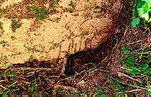 A stonemason carved the Roman letters H IIII into this stone pilaster. *Since the mason's mark is in Latin and not in Greek or Hebrew, as one might expect in Jerusalem, and since we know Herod often used Roman engineers, one might cautiously suggest that the "H" stands for Herod, who probably commissioned the construction. 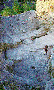 Main Street. THE ESSENE QUARTER. About 50 Essene kohanim (priests) may have lived in the southwestern corner of Jerusalem (right) between 30 B.C.E. and 70 C.E. Mostly celibate, the kohanim adhered to purity laws far stricter than those followed by Jerusalem Temple priests. The Gate of the Essenes (drawing far right), which was cut into a pre-existing city wall, gave the community access to their ritual baths, or miqva'ot, and laterines, which stood outside the city wall. Drawings by Leen Ritmeyer **I present an overview of the evidence in "Church of the Apostles Found on Mount Zion," BAR, May/June, 1990. ***The pilgrim erroneously locates David's palace on Mount Zion, although it actually stood on Jerusalem's eastern ridge. His confusion likely stems from the fact that the name "Zion" originally referred to the eastern ridge, which is now called the City of David. |
But let's return to the lowest level of the gate, which we have identified as the Gate of the Essenes. So far as we have been able to discover, this was the earliest gate in the wall at this point.9 To construct the gate, builders made a breach in the existing wall. Then they dug a sewage channel (discovered by Bliss) that ran along a street leading from the interior of the city and emptied into the Hinnom Valley, south of Mount Zion. Limestone slabs of fine workmanship cover the channel as it passes beneath the gateway. When the doyen of Israeli archaeologists, the late Benjamin Mazar, visited us, he remarked that only the workmen of Herod the Great were likely to have achieved such stonecutting perfection. The unit of measurement used at the gate was the Roman foot (11.64 inches). The outer width of the gate is exactly 9 Roman feet (105 inches). Engraved into one of the half-pilasters still preserved at the site (although not in situ) are the Roman letters H IIII, indicating that this was the fourth pilaster section supporting the lintel and arch of the gate.* The socket, in which the wings of the gate turned, remains in situ, perfectly round and smooth, suggesting that the bottom of the hinge was made of metal. The Gate of the Essenes was destroyed in 70 C.E., when Titus's Roman legionnaires razed Jerusalem.
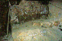
The middle sill that we discovered is part of the second gate at the site, which was built directly on the ruins of the Gate of the Essenes. It gives us a glimpse into an obscure period in Jerusalem's history, the remains of which are very scant and thus highly prized. The pottery we scraped out under this sill belongs to the second to fourth century C.E. 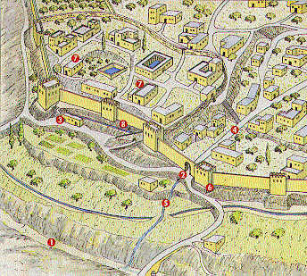
After the Romans suppressed the Second Jewish Revolt (132-135 C.E.), Jews were banned from the city. The Romans rebuilt Jerusalem as their own, renaming it Aelia Capitolina to remove any association with the Jews. They settled primarily in the present-day Old City. The southern end of Mount Zion lay outside Aelia Capitolina. In my opinion, the middle sill, built directly on top of the Gate of the Essenes, could well be part of a gate in a makeshift wall built by Jewish Christians who remained on Mount Zion even though the hill was outside the Roman city (see map, opposite). Since they had not taken part in the Second Jewish Revolt against the Romans (also called the Bar-Kokhba Revolt), these Jewish Christians were allowed to drift back to Jerusalem after Hadrian's expulsion of the Jews, especially during the beneficent reign of Antoninus Pius (138-161 C.E.). In the early third century, the Jewish Christian residents of Mount Zion appear to have erected some kind of a wall around their quarter and their synagogue.**
At this time Mount Zion was rarely visited by gentile Christians, who rather looked down on it. Around it were "cucumber fields," as observed by several church fathers, such as Eusebius, Epiphanius and Hieronymus. Nevertheless, in 333 C.E. the famous (yet anonymous) Pilgrim of Bordeaux visited this area, as noted in his Itinerary, which has survived. He relates that after leaving the Temple area he descended to the Pool of Siloam and then ascended from there, passing through the ruins of the Palace of Caiaphas, to Mount Zion. He seems to have entered Mount Zion through our gate and left it through another one: Inside, within the wall of Sion (murus Sion) appears the site, where David had his palace.*** And of the seven synagogues which had been there just a single one remains, while all the others have been plowed and tilled, just as the prophet Isaiah had said [Isaiah 1:81. When from there you go out of the wall of Sion, those proceeding to the Neapolitan Gate [Damascus Gate] have to their right side, towards the valley, the walls of the Praetorium of Pontius Pilate and to their left the hill of Golgotha.10 | ||
|
10 Pilgrim of Bordeaux, 11 itinerary," in Donato Baldi, Enchiridion Locorum Sanctorum, 3rd ed. (Jerusalem: Franciscan Printing Press, 1982), no. 16, p. 474; John Wilkinson, Egeria's Travels (London: SPCK, 1971), p. 157. 11 Pilgrim of Piacenza, "Itinerary," in Baldi, Enchiridion Locorum Sanctorum, no. 25, p. 469. |
We believe that the crudely worked middle sill of our gate was part of an entrance in this primitive "Wall of Sion," which surrounded an impoverished community of Jewish Christians shunned by other Christians as heretics because they refused to accept the doctrinal decision of the Council of Nicea (325 C.E.). The uppermost sill we date to the mid-Byzantine period (324-636 C.E.), when Christianity became the official religion of the Roman Empire and Christians ruled Jerusalem (except briefly during the seventh-century C.E. Persian invasion). The Byzantine construction-or reconstruction-of the gate is dearly indicated by the use of the Byzantine foot (12.2 inches). The width of the gate at its inner side is 10 Byzantine feet (122 inches) and at its outer side 8 Byzantine feet (97 inches).
While the earlier two gates could only be reached by a steep ascent from the Hinnom Valley, Eudocia's engineers built a road around Mount Zion, gently descending to the so-called Sultan's Pool, west of Mount Zion, and leading from there to Bethlehem. It was thus much easier for the wave of pilgrims coming from the south to enter Jerusalem. The access road built by Eudocia raises a question about the original entranceway at this site: Who would have built a gate at this unlikely location, on the shoulder of a ravine descending into the Hinnom Valley, atop a hill so steep that the gate could only be reached on foot? City gates are often called after locations to which their streets lead. Damascus Gate leads from Jerusalem to Damascus and Jaffa Gate to Jaffa, to name two of the gates in the present Old City wall. Sometimes the name indicates the function of the gate. Dung Gate probably served as the exit for garbage. The Gate of the Essenes must have been named for the people who lived there and used the gate to go in and out of Jerusalem.
Evidence that Essenes lived not only at Qumran, near the caves where the Dead Sea Scrolls were found, but also in Jerusalem comes from several sources, including the scrolls themselves (assuming the scrolls constitute an Essene library). The famous War Scroll, which describes an apocalyptic battle between the forces of light and the forces of darkness, refers to the sounding of trumpets when the victorious forces of light "return from battle against the enemy when they journey to the congregation (or community [ha-edah]) in Jerusalem."12 | ||
|
12 IQM 3.10-11; see also IQM 7 . 3-4. 13 Josephus, Jewish Antiquities 13.31 1. 14 Josephus, Jewish Antiquities 15.373. |
Josephus mentions a certain Essene teacher named Judas living in Jerusalem in 104 B.C.E.13 Later, Josephus reports, the youthful Herod the Great met an Essene named Menahem.14 According to Josephus, the Essenes were one of three major Torah schools; the other two were the Pharisees, who were mostly lay people, and the Sadducees, the aristocratic and powerful priestly class of Jerusalem. The nucleus of the Essene movement was made up of Zadokite kohanim, or priests. From the time of Solomon, the Temple's high priests had come from the house of Zadok, a son of Aaron, from whom the founders of the Essenes descended. After the successful second-century B.C.E. revolt of the Maccabees and the reestablishment of an independent Jewish state, the Hasmonean kings (from the Maccabee family) assumed not only the kingship but also the high priesthood. The king and high priest were one. The Zadokites among the Essenes considered the non-Zadokite priests usurpers and declared their Temple sacrifices illegal. The Essenes refused to take part in Hasmonean sacrificial offerings and adhered to purity rules far stricter than those the Temple authorities were enforcing. Even the Essene calendar was different. The Temple authorities maintained a lunar calendar; the Essenes followed a solar calendar, which consisted of exactly 52 weeks per year, that is, 364 days. According to this calendar, festivals always fell on the same day of the week. Thus, Rosh Hashanah (the Feast of Trumpets), Passover and the first day of Sukkot (the Feast of Tabernacles) always occurred on a Wednesday. The Essenes considered the solar calendar used by the Hasmoneans in the Temple, tied as it was to a 354-day lunar calendar, to be adulterated with Babylonian elements. For example, the names of the months-Nisan, Shevet, Adar, Tishri-were Babylonian. The difference in calendars created a terrible discrepancy in holiday observance, with the Temple authorities and the Essenes celebrating festivals on different days. This naturally created a sharp rift between the two groups.
| ||
|
1515 Josephus, Jewish Antiquities 18.20. 16 Philo, Quod omnis homo probus liber sit 75. 17 Philo, Apologia pro Judaeis 1. |
The most popular and influential of the three Torah schools was that of the Pharisees. They were less radical than the Essenes and were ready to compromise with the Sadducees and, to some extent, cooperate with the Romans. According to Josephus, the Pharisees numbered six thousand; the Essenes,, four thousand.15 The contemporaneous Jewish philosopher and exegete Philo of Alexandria gives the same number of Essenes.16 Like Josephus, Philo reports that the Essenes "are living together in large communities in several cities of Judea and in many villages."17 Because of the Essenes' strict purity rules (among other things, sexual intercourse was forbidden in Jerusalem, and at least some members were celibate), we may assume that they lived in their own section of the city. I believe that the earliest gate at our site, the Gate of the Essenes, led to the Essene quarter of Jerusalem on Mount Zion. This conclusion is supported by my discovery of yet another previously unknown landmark mentioned in Josephus's description of the First Wall - the | ||
18 Josephus, The Jewish War 5.145.
 Essene Latrines. 19 See 11QMiqdash 46.13-16, trans. in The Temple Scroll ed. Yigael Yadin, 3 vols. (Jerusalem: Israel Exploration Society/Ben Zvi, 1983), vol. 1, p. 294. |
place of the Bethso.18 According to Josephus, the Bethso lay between Hippicus Tower (near modern Jaffa Gate) and the Gate of the Essenes. Since the 19th century, most scholars have agreed that the term "Bethso" derives from the Hebrew beth-soa, or latrines. According to the longest Dead Sea Scroll, the Temple Scroll, the Essenes did build such a structure-outside their city, to the northwest-precisely where Josephus locates the Bethso. The Temple Scroll specifies: "And you shall make them a place for a hand, outside the city, to which they shall go out, to the northwest of the city, [where they shall make] roofed buildings with pits within them, into which the excrement will descend [so that] it will [not] be visible at any distance from the city, three thousand cubits." 19 The Essene law is evidently a strict interpretation of Deuteronomy 23:13: "There shall be a place for you outside the camp, where you may relieve yourself." The route described in the Temple Scroll matches the topographical situation around the Essene quarter. An Essene leaving Jerusalem through the Gate of the Essenes would turn to the northwest and follow the path between the city wall and the ravine descending into the Hinnom Valley and reach his destination at a bend in the wall near the former Bishop Gobat School. Josephus, too, notes that the Essenes selected more retired spots" to defecate.20 | ||
| 20 Josephus, Jewish War 2.149. |
The resulting frequent foot traffic through the Gate of the Essenes surely explains why its sills were so well worn. What I have identified as the remains of the Bethso appear in an 1875 diagram of the scarp of Mount Zion by Palestine Exploration Fund archaeologist Claude R. Conder. This drawing shows a platform with two converging sewage channels running parallel to the rock scarp. A military man, Captain Conder suggested that the platform might have been a horse stable that served as a hiding place from which city defenders could ambush enemy attackers. Today, a terrace is built over the platform and only the eastern corner remains visible. The discovery of several miqva'ot (singular, miqveh [ritual baths]) just outside the gate further supports the identification of this area as an Essene quarter. As I mentioned earlier, while digging near the gate we discovered some of the tunnels Bliss dug a hundred years ago. A few remained intact, among them one leading along the sewage channel. Carefully creeping through it at a depth of some 30 feet, I noticed several smaller feeder channels descending from the north. These suggested that the channel passing through the Essene Gate collected refuse water coming from throughout the quarter.
| ||
|
21 Claude R. Conder, "The Rock Scarp of Zion," Palestine Exploration Fund Quarterly Statement 7 (1875), p@ 81-89 (esp. pp. 85-86). 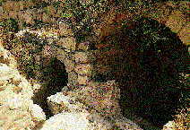
22 4QMMT, line 60. 23 4QMMT, line 15; see also 11 QT 50.4,15; 51.5. 24 See IQS 5.13ff; CD 10.10-13
|
Working in that direction we found a double miqveh about 160 feet from the gate. Originally discovered more than a hundred years ago by Claude Conder, these miqva'ot were just outside the ancient city wall and were situated on top of a rock shelf, from which one could descend 36 steps to a garden level with the Gate of the Essenes.21 One of the two baths had a divider between the steps of descent and the steps of ascent, as also appears in the Qumran miqva'ot. Presumably, the steps of ascent were for the purified bather to emerge without recontamination.
A small secret entrance to the city via a pastern gate barely 4 feet wide was adjacent to the miqva'ot on the rock platform out of which they were carved. Once the sun set, the purified bathers could reenter the Essene quarter quietly and privately.
As I write these words, I look out my window onto the so-called Greek Garden attached to the nearby Greek Orthodox seminary. In this very garden, we found two ancient ritual baths. One was recently covered up; the other remains open. Ritual baths are, of course, common in excavations all over Jerusalem. Those for families are comparatively small, while those that served the public, like the baths found in the Temple compound, are much larger. The baths we found are very large and compare in size with those in Qumran. The one that is still open in the Greek Garden is 35 feet long and nearly 14 feet wide. Not even in Qumran is there such a large miqveh. Clearly, the Greek Garden miqva'ot were not meant for family use but served a community. | ||
|
25 A preliminary survey and radar ground-scan work have recently been carried out in the Greek Garden on Mount Zion by Professor James Strange of the University of South Florida, supported by the Foundation for Biblical Archaeology of Goldsboro, North Carolina; CenturyOne Foundation of Pasadena, California; and the Kuhn Foundation of Irvine, California. Perhaps future exploratory efforts will reveal the material level of habitation in this important area of the city at various periods.
|
I believe we now have sufficient evidence not only to identify our gate as the Gate of the Essenes but also to conclude that a community of Essenes lived here on Mount Zion in Jesus' time. 25 This article appeared in the May/June 1997 issue of the Biblical Archaeology Review. Copyright ©1997 Biblical Archaeology Society The Biblical Archaeology Review is published every other month by the Biblical Archaeology Society, a non-profit society, 4710 41st Street, NW Washingotn, D.C. 20016 Subscription price is $27.00 per year in the United States, $33.00 elsewhere. Editor: Hershel Shanks E-mail: BAS@bib-arch.org Pixner's Church of the Apostles Found on Mt. Zion Biblical Archaeology Review | ||
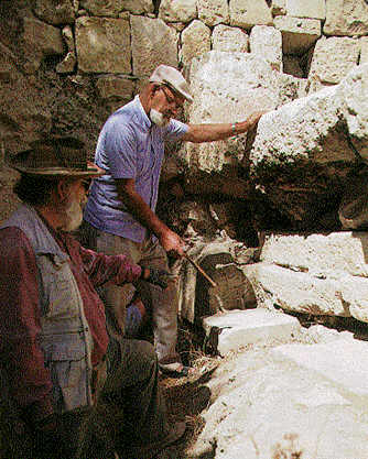 To appreciate Bliss's achievement, one must understand how archaeology was done in those early days. Candles provided the only lighting as Bliss and his crew worked like moles 10 to 15 feet below ground, digging and crawling through tunnels only 2 to 3 feet in diameter. When Bliss reached the gate, he opened a crater to the surface. We came across some of Bliss's tunnels in our own excavations.
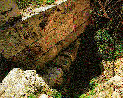 Unfortunately, we could not make a stratigraphic study of the area around the superimposed sills because Bliss had completely disturbed the strata. We did manage, however, to extract some ceramic sherds from beneath the lowest, and therefore earliest, of the three sills. Coming from a sealed-off, undisturbed location, the sherds provided a reliable indication of the date of the first gate at the site. All our experts agreed that the pottery beneath the lowest threshold predated 70 C.E., the year of the destruction of Jerusalem by the troops of the Roman general Titus, son of Emperor Vespasian. We had little doubt that this was the gate Josephus called the Gate of the Essenes.6
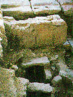 The sill we discovered from this period consists of two limestone slabs bonded together with cement plaster. Apparently, this second gate had a stepped sill. the lower slab is broken off at a slant, indicating that the gate was made of material gathered at random. In the corner of the lower slab is a rather shapeless hinge socket, indicating that the gate hinge also was not well formed. The socket is clearly more primitive than the one on the earlier gate. We found two coins, one outside and one inside the gate, of the Emperor Heliogabalus (218222 C.E.). Repair work may have been done on the gate or the sewage channel during his reign.
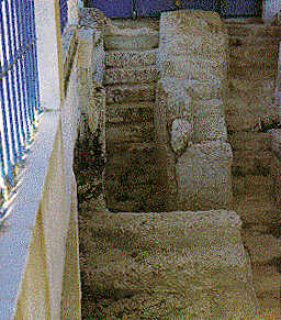 That these Jerusalem miqva'ot are outside the wall is significant. Deuteronomy 23:11-12 states that when someone contracts impurity because of a nocturnal emission (remember that many of the Essenes were celibate), "he must go outside the camp; he must not come within the camp. When evening comes, he must wash himself with water. When the sun has set, he may come back into the camp." The Essenes regarded the entire city of Jerusalem as equivalent to the camp (one scroll reads "Jerusalem is the camp of holiness"22). They must have purified themselves in these miqva'ot before reentering their quarter of the city. The Essenes interpreted these laws of purity very strictly. The Pharisees regarded purification from a variety of causes as effective immediately upon emergence from the miqveh. But the Essenes insisted on waiting until sunset in strict accordance with the instruction in Deuteronomy. 23